Yes, We have Volcanos!
- Neil Björklund

- Sep 21, 2022
- 6 min read
Updated: Feb 21, 2024
I've been known to describe my avocation of chasing butterflies in Oregon as a game played on the huge game board of the state of Oregon--"the Big Game Board." There's something about these lines drawn on a map, whether they be county or state boundaries, that inspires me to make up rules for a game in a way that motivates me to get organized, get out of the house, and go find something wonderful in nature on a regular basis. I play this game with both butterflies and birds, and I seem to gravitate most often to playing on the "Little Game Board" of Lane County, and on the "Big Game Board" of Oregon. I use these human delineations of the physical landscape to add an element of fun and challenge to my outdoor adventures.
Back in August of 2020, I visited Crater Lake to look for two of our as-yet undescribed Blues, the Pumice Blue ("Square-spotted Blue" on Eriogonum marifolium) and the Shasta Blue (Icaricia on E. pyrolifolium var. coryphaeum). After finding both species at Crater Lake, and full of curiosity, I then hiked up into the pumice flats of Wickiup Plain near South Sister to look there. I wanted to find these species in Lane County if I could, and I did find them, which was a lot of fun. Later that fall, my colleague Lori Humphreys, an excellent butterflier and naturalist, told me she'd seen the Volcano Blue in Lane County, on the top of Twins Peak back in 2011. Ever since she told me that, I'd wanted to go see if the Volcano Blue is still there, in Lane County, and photo-document it--playing the game on the Little Game Board!

I started a round of the game late last July, when I made the 3 mile, 1500-foot climb to Twins Peak, at over 7,000 feet elevation. Twins Peak is just east of Waldo Lake, in the central Cascade Mountains. On that visit last July, the weather was less than ideal and there was a lot of wildfire smoke around. The weather changed dramatically almost as soon as I got to the steep cinder fields on the west flank of the peaks, and clouds, wind and finally rain, soon drove me off the peak. I saw one blue that day I thought could be a Volcano Blue, but it was pretty beat up and not what I could call definitive.
Undaunted by "losing" that round of the game, I planned this year's visit to coincide with the timing of last year's trip to Crater Lake, which was about a week into August. That timing looked like it might have been the peak of the flight season, so I decided to try that again. I knew that there were a couple of wildfires burning near Oakridge, Oregon and that there was the possibility that there would be too much smoke around Twins Peak to make the hike. I certainly didn't want to be sucking in smoky air while climbing up the peak for 90 minutes, but I also didn't want to wait another year for Round 2 of the game.
Indeed as I drove through Oakridge, the valley was thick with smoke, and my heart dropped. But, having come that far, I thought it would be worth it to continue a bit further and see which way the smoke was blowing.

When I got to the Waldo Lake Road, I saw blue skies to the north and east. Game on! At least I could make the hike up while breathing fresh air, and see what, if any, butterflies were flying near the summit.
I hiked pretty fast through the forest, recalling my last time through, when mosquitoes buzzed, chased and bit me all through the forest. My strategy this time was to not stop and to move quickly enough that the mosquitoes might be able to follow the trail of carbon dioxide I was leaving behind, but not actually catch up to me. In case you didn't know, mosquitoes can detect concentrations of carbon dioxide (which we breathe out), and that's one of the ways they find us, even in the dark. My strategy worked pretty well, as I only got bit a couple times on the walk.

I was glad when I got to the part of the trail that starts to rise more steeply towards the peak, as the mosquies tend to thin out there. As I reached the lower portion of the cinder field on the west slope, right away I began to see Marumleaf Buckwheat (Eriogonum marifolium), the host plant for the Pumice Blue. The blooms were past their prime, but still standing. I saw just one small Euphilotes blue hanging around a Marumleaf Buckwheat plant, and got just enough of a look at it to confirm its identity. Based on the location, its association with this buckwheat species and its Euphilotes markings, I knew it was Pumice Blue. It was the only Pumice Blue I would see all afternoon. Likely, I was a bit late for the Pumice Blue flight period at this location.

As I moved up into the cinder field, I started to also see scattered Shasta Buckwheat (Eriogonum pyrolifolium var. coryphaeum) plants, which are the host plant for the Volcano Blue. These were in various stages of bloom and senescence, but many were still quite fresh. "Excellent!" I said aloud to no one in particular.
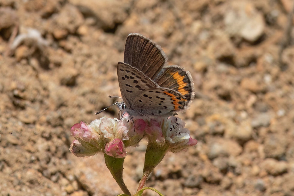
Not long after that I spotted a blue on a Shasta Buckwheat bloom. I carefully made my way closer to the plant, negotiating the slip-n-slide cinder so as not to stumble and spook the butterfly. I got my bins on it, and, voila! Volcano Blue! I don't really know why it made me so happy that Volcano Blue was surviving on the Lane County side of Twins Peak, but it did. Sure, I'd "won" this round of the game, but it felt like there was something deeper there, too. Something personal.

As I slowly continued working my way up the trail, I got several photos of both male and female Volcano Blues, almost always on their host plant--how convenient! I was headed towards the boundary between Lane County and Deschutes County, which cuts a north-south line just a stone's throw east of the two summits. The red cinder field where I'd found the Volcano Blues lay on the west-facing Lane County side. I was curious to see what else was flying so I continued up the trail towards the summit, crossing into Deschutes County.

Closer to the summit of the north peak I found several more species, in very small numbers--several species represented by just one individual. I was surprised to find that Volcano Blues were the most numerous species, at a whopping 7 individuals. Three Hydaspe Fritillaries

(Speyeria hydaspe) worked hard to elude identification by consistently landing at an angle that prevented me from seeing their ventral disc pattern. However, with patience I got closer and better angle to see their reddish ventral disc and pinkish submarginal band. A couple of male Anna's Blues (Plebejus anna) working the edges of openings in the forest looked huge compared to the smaller Volcano and Pumice blues.
I ate lunch facing a grand view out over the central High Desert, entertained by a Mormon Fritillary (Speyeria mormonia) dancing from flower to flower, and a Yellow-bellied Marmot (Marmota flaviventris) who watched me warily from its rocky perch down the steep eastern slope.
After lunch, before heading up the south peak, I walked back to the west side to check on the wind and weather conditions. I immediately saw that the smoke plume from the massive Cedar Creek Fire was now headed my way. I passed on the south peak and paused for a moment to ponder what was happening down there, where that smoke was billowing out of the forest, west of Waldo Lake. It was painful to let it sink in... Sigh. Okay, time to skedaddle back down the trail.
Last year when I visited Wickiup Plain at the base of South Sister, I had found and photographed Shasta Blue (Icaricia shasta) and Pumice Blue in Lane County. This year, I felt a certain glow of satisfaction to be able to confirm that the Volcano Blue, our other high elevation blue of dry pumice and cinder habitat, is also living in Lane County.
It's fun to play the game on these big, beautiful game boards, but that deeper feeling is also there. It has something to do with feeling connected to this land around me. It's important to me, and in some way, I hope to be important to it, to contribute to it. So I learn and share, and I hope to inspire others to know and love and care for this beautiful place we live in. That's more than a game, it's more a way of life.
I saw a total of 8 species on the upper slopes of Twins Peak. Interestingly, all the blues were on the Lane County side, and all the other species were east of the line in Deschutes County.


Love your blog Neil; I’ve read them all. If you ever venture over to my part of Idaho we’ll hike to one of my favorite spots and find some Compton Tortoiseshells!